
Doe een donatie
Rust jezelf uit voor je volgende avontuur:
Als Amazon-partner verdient deze site een commissie op in aanmerking komende aankopen, zonder extra kosten voor jou.
Topografische kaart Landeck
Klik op de kaart om de hoogte weer te geven.
Doe een donatie
Rust jezelf uit voor je volgende avontuur:
Als Amazon-partner verdient deze site een commissie op in aanmerking komende aankopen, zonder extra kosten voor jou.
Landeck
Landeck is located in the Tyrolean Oberland in the west of the state at an elevation of about 820 m (2,690 ft). The town is situated in the valley of the Inn River at the confluence with the Sanna tributary, between the Lechtal Alps, part of the Northern Limestone Alps in the north, and the Ötztal Alps and Samnaun Alps ranges of the Central Eastern Alps in the south.
Doe een donatie
Rust jezelf uit voor je volgende avontuur:
Als Amazon-partner verdient deze site een commissie op in aanmerking komende aankopen, zonder extra kosten voor jou.
Over deze kaart
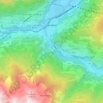
Naam: Topografische kaart Landeck, hoogte, reliëf.
Locatie: Landeck, Bezirk Landeck, 6500, Austria (47.09818 10.52642 47.15665 10.60537)
Gemiddelde hoogte: 1.325 m
Minimale hoogte: 764 m
Maximale hoogte: 2.582 m
Doe een donatie
Rust jezelf uit voor je volgende avontuur:
Als Amazon-partner verdient deze site een commissie op in aanmerking komende aankopen, zonder extra kosten voor jou.
Andere topografische kaarten
Klik op een kaart om zijn topografie, zijn hoogte en zijn reliëf te bekijken.