
Doe een donatie
Rust jezelf uit voor je volgende avontuur:
Als Amazon-partner verdient deze site een commissie op in aanmerking komende aankopen, zonder extra kosten voor jou.
Topografische kaart El Mortiño
Klik op de kaart om de hoogte weer te geven.
Doe een donatie
Rust jezelf uit voor je volgende avontuur:
Als Amazon-partner verdient deze site een commissie op in aanmerking komende aankopen, zonder extra kosten voor jou.
Over deze kaart
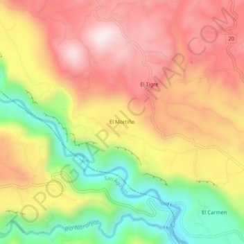
Naam: Topografische kaart El Mortiño, hoogte, reliëf.
Gemiddelde hoogte: 1.591 m
Minimale hoogte: 1.262 m
Maximale hoogte: 1.858 m
Doe een donatie
Rust jezelf uit voor je volgende avontuur:
Als Amazon-partner verdient deze site een commissie op in aanmerking komende aankopen, zonder extra kosten voor jou.
Andere topografische kaarten
Klik op een kaart om zijn topografie, zijn hoogte en zijn reliëf te bekijken.
Parque Nacional Natural Puracé
El parque nacional natural Puracé se encuentra en la reserva de biosfera del cinturón andino, región del Macizo Colombiano perteneciente a la cordillera Central de los Andes en Colombia. Su superficie hace parte de los departamentos del Cauca y del Huila. Su altitud es de 4646 msnm; en el parque se…
Gemiddelde hoogte: 2.708 m