
Topografische kaart Indio
Interactieve kaart
Klik op de kaart om de hoogte weer te geven.
Over deze kaart
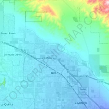
Naam: Topografische kaart Indio, hoogte, reliëf.
Locatie: Indio, Riverside County, California, United States (33.67100 -116.30127 33.81671 -116.12929)
Gemiddelde hoogte: 74 m
Minimale hoogte: -30 m
Maximale hoogte: 782 m
Indio is home of Riverside County's eastern administration offices. Palm Springs had more people from 1955 to 1992, when the US census announced that Indio surpassed Palm Springs and that title was returned to them. The official elevation of Indio is below sea level; the city hall is 14 feet (4 m) below sea level, as the eastern half of the Coachella Valley drops as low as 150 feet (50 m) below sea level (the lakeshore of the Salton Sea is 15 miles (24 km) south of Indio).
Andere topografische kaarten
Klik op een kaart om zijn topografie, zijn hoogte en zijn reliëf te bekijken.
Joshua Tree National Park
United States > California > Riverside County
Joshua Tree National Park, Riverside County, California, United States
Gemiddelde hoogte: 639 m
Moreno Valley
United States > California > Riverside County
Moreno Valley, Riverside County, California, United States
Gemiddelde hoogte: 527 m
Canyon Lake
United States > California > Riverside County > Canyon Lake
Canyon Lake, Riverside County, California, United States
Gemiddelde hoogte: 461 m
Indian Wells
United States > California > Riverside County > Indian Wells
Indian Wells, Riverside County, California, 92210, United States
Gemiddelde hoogte: 118 m
Corona
United States > California > Riverside County
Corona, Riverside County, CAL Fire Southern Region, California, United States
Gemiddelde hoogte: 377 m
Lake Elsinore
United States > California > Riverside County > Lake Elsinore > Lake Elsinore
Lake Elsinore, Riverside County, California, 92532, United States
Gemiddelde hoogte: 428 m
Coachella
United States > California > Riverside County > Coachella
Coachella, Riverside County, California, 92236, United States
Gemiddelde hoogte: 22 m
Palm Springs
United States > California > Riverside County
Palm Springs, Riverside County, California, United States
Gemiddelde hoogte: 698 m
Mesa Verde
United States > California > Riverside County > Mesa Verde
Mesa Verde, Riverside County, California, United States
Gemiddelde hoogte: 120 m
Riverside
United States > California > Riverside County > Riverside
Riverside, Riverside County, California, United States
Gemiddelde hoogte: 351 m
Murrieta
United States > California > Riverside County
Murrieta, Riverside County, California, United States
Gemiddelde hoogte: 454 m