
Topografische kaart Elizabethton
Interactieve kaart
Klik op de kaart om de hoogte weer te geven.
Over deze kaart
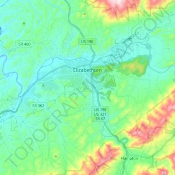
Naam: Topografische kaart Elizabethton, hoogte, reliëf.
Gemiddelde hoogte: 567 m
Minimale hoogte: 433 m
Maximale hoogte: 1.016 m
The elevation at Elizabethton Municipal Airport is 1,593 feet (486 m) ASL (the highest point of elevation in Carter County is at Roan Mountain with an elevation of 6,285 feet (1,916 m) ASL), and the airport is located on the eastern side of the city along State Highway 91 Stoney Creek Exit. Elizabethton is also connected to larger commercial, shuttle, and cargo flights out of Tri-Cities Regional Airport northwest of Johnson City.
Andere topografische kaarten
Klik op een kaart om zijn topografie, zijn hoogte en zijn reliëf te bekijken.
Elizabethton
United States > Tennessee > Carter County > Elizabethton > Elizabethton
Elizabethton, Carter County, Tennessee, 37643, United States
Gemiddelde hoogte: 527 m
Roan Mountain
United States > Tennessee > Carter County
Roan Mountain, Carter County, East Tennessee, Tennessee, United States
Gemiddelde hoogte: 1.418 m
Pine Crest
United States > Tennessee > Carter County
Pine Crest, Carter County, East Tennessee, Tennessee, United States
Gemiddelde hoogte: 515 m
Tolley Town
United States > Tennessee > Carter County
Tolley Town, Carter County, East Tennessee, Tennessee, United States
Gemiddelde hoogte: 896 m
Winner
United States > Tennessee > Carter County
Winner, Carter County, East Tennessee, Tennessee, United States
Gemiddelde hoogte: 614 m
Roan Mountain State Park
United States > Tennessee > Carter County > Roan Mountain
Roan Mountain State Park, Roan Mountain, Carter County, East Tennessee, Tennessee, United States
Gemiddelde hoogte: 988 m
Watauga Lake
United States > Tennessee > Carter County
Watauga Lake, Carter County, Tennessee, 37640, United States
Gemiddelde hoogte: 755 m
Central
United States > Tennessee > Carter County
Central, Carter County, East Tennessee, Tennessee, United States
Gemiddelde hoogte: 489 m
Roan Mountain
United States > Tennessee > Carter County
Roan Mountain, Carter County, East Tennessee, Tennessee, 37687, United States
Gemiddelde hoogte: 926 m
Elk Mills
United States > Tennessee > Carter County
Elk Mills, Carter County, Tennessee, United States
Gemiddelde hoogte: 749 m
Dogtown
United States > Tennessee > Carter County
Dogtown, Carter County, Tennessee, United States
Gemiddelde hoogte: 617 m
Jane Bald
United States > Tennessee > Carter County
Jane Bald, Carter County, East Tennessee, Tennessee, United States
Gemiddelde hoogte: 1.573 m
Watauga
United States > Tennessee > Carter County
Watauga, Carter County, East Tennessee, Tennessee, United States
Gemiddelde hoogte: 465 m
Hunter
United States > Tennessee > Carter County
Hunter, Carter County, Tennessee, United States
Gemiddelde hoogte: 706 m
Milligan
United States > Tennessee > Carter County > Elizabethton > Milligan
Milligan, Elizabethton, Carter County, Tennessee, 37605, United States
Gemiddelde hoogte: 508 m
Hampton
United States > Tennessee > Carter County
Hampton, Carter County, East Tennessee, Tennessee, 37658, United States
Gemiddelde hoogte: 674 m
Valley Park
United States > Tennessee > Carter County > Elizabethton > Valley Park
Valley Park, Elizabethton, Carter County, Tennessee, 37643, United States
Gemiddelde hoogte: 515 m