
Topografische kaart Rumford
Interactieve kaart
Klik op de kaart om de hoogte weer te geven.
Over deze kaart
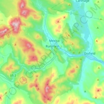
Naam: Topografische kaart Rumford, hoogte, reliëf.
Locatie: Rumford, Oxford County, Maine, 04276, United States (44.45720 -70.73271 44.61602 -70.48286)
Gemiddelde hoogte: 279 m
Minimale hoogte: 115 m
Maximale hoogte: 708 m
According to the United States Census Bureau, the town has a total area of 69.85 square miles (180.91 km2), of which 68.55 square miles (177.54 km2) is land and 1.30 square miles (3.37 km2) is water. Rumford is located where the Concord, Ellis, and Swift rivers drain into the Androscoggin river. Black Mountain, elevation 2,133 feet (650 m), and Rumford Whitecap, elevation 2,197 feet (670 m), are in the north.
Andere topografische kaarten
Klik op een kaart om zijn topografie, zijn hoogte en zijn reliëf te bekijken.
Sugarloaf
United States > Maine > Oxford County > Dixfield
Sugarloaf, Dixfield, Oxford County, Maine, 04224, United States
Gemiddelde hoogte: 237 m
Greenwood
United States > Maine > Oxford County
Greenwood, Oxford County, Maine, 04255, United States
Gemiddelde hoogte: 295 m
Milton Township
United States > Maine > Oxford County
Milton Township, Oxford County, Maine, 04219, United States
Gemiddelde hoogte: 309 m
Pleasant Lake
United States > Maine > Oxford County > Otisfield
Pleasant Lake, Otisfield, Oxford County, Maine, 04270, United States
Gemiddelde hoogte: 140 m
Paris
United States > Maine > Oxford County
Paris, Oxford County, Maine, 04281, United States
Gemiddelde hoogte: 207 m
Woodstock
United States > Maine > Oxford County
Woodstock, Oxford County, Maine, 04219, United States
Gemiddelde hoogte: 316 m
Upton
United States > Maine > Oxford County
Upton, Oxford County, Maine, 04261, United States
Gemiddelde hoogte: 448 m
West Paris
United States > Maine > Oxford County
West Paris, Oxford County, Maine, 04289, United States
Gemiddelde hoogte: 234 m
Bethel
United States > Maine > Oxford County
Bethel, Oxford County, Maine, 04217, United States
Gemiddelde hoogte: 310 m
Stow
United States > Maine > Oxford County
Stow, Oxford County, Maine, 04037, United States
Gemiddelde hoogte: 308 m
Plumbago Mountain
United States > Maine > Oxford County > Newry
Plumbago Mountain, Newry, Oxford County, Maine, 04261, United States
Gemiddelde hoogte: 618 m
Denmark
United States > Maine > Oxford County
Denmark, Oxford County, Maine, 04022, United States
Gemiddelde hoogte: 174 m
South Paris
United States > Maine > Oxford County > Paris
South Paris, Paris, Oxford County, Maine, 04281, United States
Gemiddelde hoogte: 155 m
Sweden
United States > Maine > Oxford County
Sweden, Oxford County, Maine, 04040, United States
Gemiddelde hoogte: 185 m
Norway
United States > Maine > Oxford County
Norway, Oxford County, Maine, 04268, United States
Gemiddelde hoogte: 180 m