
Topografische kaart Fuhai
Interactieve kaart
Klik op de kaart om de hoogte weer te geven.
Fuhai
The Altai Mountains traverses Fuhai County, and the two main rivers in the county are the Ulungu Lake and the Irtysh River. Ulungu Lake is located in Fuhai County. The county's elevation ranges from 386 to 3,332 m (1,266 to 10,932 ft), with an average elevation of about 500 m (1,640 ft).
Over deze kaart
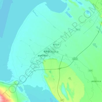
Naam: Topografische kaart Fuhai, hoogte, reliëf.
Locatie: Fuhai, Fuhai County, Altay Prefecture, Xinjiang, 836400, China (46.95149 87.32375 47.27149 87.64375)
Gemiddelde hoogte: 504 m
Minimale hoogte: 479 m
Maximale hoogte: 715 m