
Topografische kaart Lubniewice
Interactieve kaart
Klik op de kaart om de hoogte weer te geven.
Over deze kaart
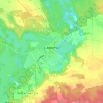
Naam: Topografische kaart Lubniewice, hoogte, reliëf.
Gemiddelde hoogte: 70 m
Minimale hoogte: 28 m
Maximale hoogte: 129 m
Andere topografische kaarten
Klik op een kaart om zijn topografie, zijn hoogte en zijn reliëf te bekijken.
Warta River Mouth National Park
Poland > Lubusz Voivodeship > Sulęcin County
Warta River Mouth National Park, Sulęcin County, Lubusz Voivodeship, Poland
Gemiddelde hoogte: 27 m