
Topografische kaart Dunmore
Interactieve kaart
Klik op de kaart om de hoogte weer te geven.
Over deze kaart
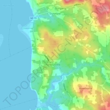
Naam: Topografische kaart Dunmore, hoogte, reliëf.
Gemiddelde hoogte: 28 m
Minimale hoogte: -1 m
Maximale hoogte: 100 m
Andere topografische kaarten
Klik op een kaart om zijn topografie, zijn hoogte en zijn reliëf te bekijken.
Mabou Harbour
Canada > Nova Scotia > Municipality of the County of Inverness > West Mabou
Mabou Harbour, West Mabou, Municipality of the County of Inverness, Inverness County, Nova Scotia, Canada
Gemiddelde hoogte: 51 m
Big Harbour Island
Canada > Nova Scotia > Municipality of the County of Inverness
Big Harbour Island, Municipality of the County of Inverness, Inverness County, Nova Scotia, Canada
Gemiddelde hoogte: 3 m
Gull Island
Canada > Nova Scotia > Municipality of the County of Inverness > Big Harbour Island
Gull Island, Big Harbour Island, Municipality of the County of Inverness, Inverness County, Nova Scotia, Canada
Gemiddelde hoogte: 74 m