
Topografische kaart Tenkiller Ferry Lake
Interactieve kaart
Klik op de kaart om de hoogte weer te geven.
Over deze kaart
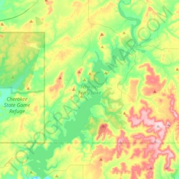
Naam: Topografische kaart Tenkiller Ferry Lake, hoogte, reliëf.
Gemiddelde hoogte: 258 m
Minimale hoogte: 150 m
Maximale hoogte: 448 m
The hydroelectric power station is remotely controlled from the control center at Fort Gibson Lake. Two generators, each rated for 17 megawatts, provide a total capacity of 34 megawatts (MWe). The facility can handle 40 MWe for a short period of time. However, the amount of power that can actually be generated depends heavily on the lake elevation at any given time.