
Topografische kaart Fall City
Klik op de kaart om de hoogte weer te geven.
Fall City
The Fall City Airport is a small private airport community located 2 miles (3 km) east of the community at latitude 47-33-34.366 N and longitude 121-51-49.413 W, at an elevation of 140 feet (43 m) above sea level. The airport is owned by the Fall City Airport Association. It has no air traffic control tower.[8]
Over deze kaart
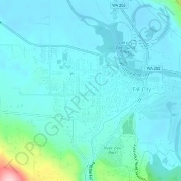
Naam: Topografische kaart Fall City, hoogte, reliëf.
Locatie: Fall City, King County, Washington, United States (47.55409 -121.92178 47.57775 -121.88330)
Gemiddelde hoogte: 48 m
Minimale hoogte: 20 m
Maximale hoogte: 230 m
Andere topografische kaarten
Klik op een kaart om zijn topografie, zijn hoogte en zijn reliëf te bekijken.
West Hylebos Wetlands Park
United States > Washington > King County > Federal Way
Gemiddelde hoogte: 84 m
Stevens Pass
United States > Washington > King County
Stevens Pass (elevation 4,061 ft (1,238 m)) is a mountain pass through the Cascade Mountains located at the border of King County and Chelan County in Washington, United States. U.S. Route 2 travels over the pass, reaching a maximum elevation of 4,061 feet (1,238 m). The Pacific Crest Trail crosses the highway…
Gemiddelde hoogte: 1.387 m
Preston
United States > Washington > King County
Preston is a historic mill town on the northeast edge of the large Tiger Mountain State Forest, along Interstate 90. Preston, elevation 430 ft (130 m), is located within commuting distance of Seattle and Bellevue.
Gemiddelde hoogte: 270 m
Mount Si
United States > Washington > King County
The peak can be accessed by two trails. The Old Mount Si trail is accessed by the Little Si parking lot and the Boulder Garden Loop. It is 0.6 miles (0.97 km) shorter, 270 feet (82 m) steeper in elevation gain, and less crowded than the main trail. The Mount Si trail is accessed by the Mount Si parking lot.
Gemiddelde hoogte: 793 m
Hot Springs
United States > Washington > King County
Hot Springs is located east of Enumclaw and just west of Lester, along the Green River and BNSF Railway line. Its elevation is 1512 feet (460m) above sea level.
Gemiddelde hoogte: 588 m
Stampede Pass
United States > Washington > King County
Stampede Pass (elevation 3,672 feet (1,119 m)) is a mountain pass in the northwest United States, through the Cascade Range in Washington. Southeast of Seattle and east of Tacoma, its importance to transportation lies almost entirely with railroading, as no paved roads cross it. It is approximately twelve…
Gemiddelde hoogte: 1.135 m
Mercer Island
United States > Washington > King County > Mercer Island
Mercer Island City Hall is located at 47°34′39″N 122°12′43.2″W / 47.57750°N 122.212000°W / 47.57750; -122.212000 (47.5775, -122.212). The peak elevation in the city is about 338 feet (103 m), near the center of the island.
Gemiddelde hoogte: 39 m
Mount Index
United States > Washington > King County
Mount Index is a peak in the central part of the Cascade Range of Washington state. It lies just south of the Skykomish River and U.S. Route 2, at the western edge of the Cascades. Despite its low elevation relative to peaks higher in the Cascades, it is a famous and dramatic landmark due to its topographic…
Gemiddelde hoogte: 1.178 m
Mount Si
United States > Washington > King County
The peak can be accessed by two trails. The Old Mount Si trail is accessed by the Little Si parking lot and the Boulder Garden Loop. It is 0.6 miles (0.97 km) shorter, 270 feet (82 m) steeper in elevation gain, and less crowded than the main trail. The Mount Si trail is accessed by the Mount Si parking lot.
Gemiddelde hoogte: 787 m
Maple Valley
United States > Washington > King County > Maple Valley > Maple Valley
Gemiddelde hoogte: 166 m
Lester
United States > Washington > King County
Lester is located, east of Enumclaw, Washington along the Green River and BNSF Railway line. Its elevation is 1,634 feet (498 m) above sea level.
Gemiddelde hoogte: 690 m
Hot Springs
United States > Washington > King County
Hot Springs is located east of Enumclaw and just west of Lester, along the Green River and BNSF Railway line. Its elevation is 1512 feet (460m) above sea level.
Gemiddelde hoogte: 588 m
Mount Si
United States > Washington > King County
The peak can be accessed by two trails. The Old Mount Si trail is accessed by the Little Si parking lot and the Boulder Garden Loop. It is 0.6 miles (0.97 km) shorter, 270 feet (82 m) steeper in elevation gain, and less crowded than the main trail. The Mount Si trail is accessed by the Mount Si parking lot.
Gemiddelde hoogte: 787 m
Lake Forest Park
United States > Washington > King County > Lake Forest Park > Lake Forest Park
Gemiddelde hoogte: 85 m