
Topografische kaart Great Basin National Park
Interactieve kaart
Klik op de kaart om de hoogte weer te geven.
Over deze kaart
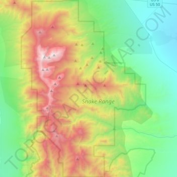
Naam: Topografische kaart Great Basin National Park, hoogte, reliëf.
Gemiddelde hoogte: 2.352 m
Minimale hoogte: 1.566 m
Maximale hoogte: 3.938 m
The park derives its name from the Great Basin, the dry and mountainous region between the Sierra Nevada and the Wasatch Mountains. Topographically, this area is known as the Basin and Range Province. The park is located about 290 miles (470 km) north of Las Vegas and protects 77,180 acres (31,230 ha).
Andere topografische kaarten
Klik op een kaart om zijn topografie, zijn hoogte en zijn reliëf te bekijken.
Baker
United States > Nevada > White Pine County
Baker, White Pine County, Nevada, 89311, United States
Gemiddelde hoogte: 1.632 m
Lehman Caves
United States > Nevada > White Pine County
Lehman Caves, Lehman Caves Road, White Pine County, Nevada, United States
Gemiddelde hoogte: 2.143 m
Lund
United States > Nevada > White Pine County
Lund, White Pine County, Nevada, 89317, United States
Gemiddelde hoogte: 1.757 m
Red Rocks
United States > Nevada > White Pine County
Red Rocks, White Pine County, Nevada, United States
Gemiddelde hoogte: 1.912 m
Ely
United States > Nevada > White Pine County
Ely, White Pine County, Nevada, 89301, United States
Gemiddelde hoogte: 2.045 m
Mount Moriah
United States > Nevada > White Pine County
Mount Moriah, White Pine County, Nevada, United States
Gemiddelde hoogte: 3.295 m