
Doe een donatie
Rust jezelf uit voor je volgende avontuur:
Als Amazon-partner verdient deze site een commissie op in aanmerking komende aankopen, zonder extra kosten voor jou.
Topografische kaart Mancos
Klik op de kaart om de hoogte weer te geven.
Doe een donatie
Rust jezelf uit voor je volgende avontuur:
Als Amazon-partner verdient deze site een commissie op in aanmerking komende aankopen, zonder extra kosten voor jou.
Mancos
According to the United States Census Bureau, Mancos has a total area of 0.6 square miles (1.6 km2), all of it recorded as land. The town is located in the Mancos River valley at an elevation of approximately 7,000 feet (2,100 m). The Mancos River was named by Spanish explorers (Rio de los Mancos - "River of the Sleeve") perhaps for the way the river, which rises in the La Plata Mountains northeast of Mancos, drains the valley and then flows into the narrow confines of Weber Canyon and Mancos Canyon, southwest of Mesa Verde, where it joins the San Juan River. The town's skyline is dominated by the mass of Mesa Verde 7 miles (11 km) to the west, Menefee Mountain 2 miles (3 km) to the southeast, and the La Plata Mountains, a range to the east and northeast, in which the headwaters of the Mancos River originate.
Doe een donatie
Rust jezelf uit voor je volgende avontuur:
Als Amazon-partner verdient deze site een commissie op in aanmerking komende aankopen, zonder extra kosten voor jou.
Over deze kaart
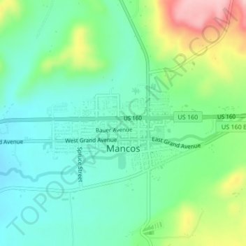
Naam: Topografische kaart Mancos, hoogte, reliëf.
Locatie: Mancos, Montezuma County, Colorado, United States (37.34148 -108.30495 37.35229 -108.28236)
Gemiddelde hoogte: 2.158 m
Minimale hoogte: 2.104 m
Maximale hoogte: 2.284 m
Doe een donatie
Rust jezelf uit voor je volgende avontuur:
Als Amazon-partner verdient deze site een commissie op in aanmerking komende aankopen, zonder extra kosten voor jou.
Andere topografische kaarten
Klik op een kaart om zijn topografie, zijn hoogte en zijn reliëf te bekijken.
Cortez
United States > Colorado > Montezuma County > Cortez
Cortez has a dry-summer continental climate (Köppen Dsb), though it borders on a semi-arid climate (BSk) due to low precipitation. The city has hot summer days and cold winter nights, the latter a result of its elevation.
Gemiddelde hoogte: 1.869 m
Doe een donatie
Rust jezelf uit voor je volgende avontuur:
Als Amazon-partner verdient deze site een commissie op in aanmerking komende aankopen, zonder extra kosten voor jou.