
Topografische kaart City of Durham
Interactieve kaart
Klik op de kaart om de hoogte weer te geven.
Over deze kaart
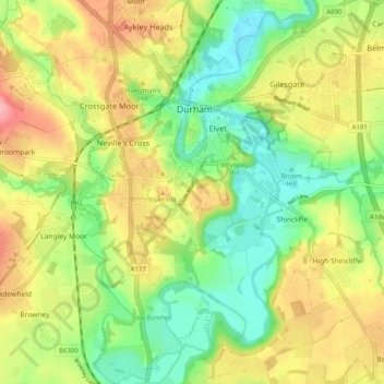
Naam: Topografische kaart City of Durham, hoogte, reliëf.
Gemiddelde hoogte: 76 m
Minimale hoogte: 26 m
Maximale hoogte: 139 m
Andere topografische kaarten
Klik op een kaart om zijn topografie, zijn hoogte en zijn reliëf te bekijken.
Observatory Hill
United Kingdom > England > County Durham > Durham
Observatory Hill, Durham, County Durham, North East, England, DH1 4SZ, United Kingdom
Gemiddelde hoogte: 73 m
Pelton Fell
United Kingdom > England > County Durham > Durham
Pelton Fell, Durham, County Durham, North East, England, DH2 2QA, United Kingdom
Gemiddelde hoogte: 76 m
Flass Vale Local Nature Reserve
United Kingdom > England > County Durham > Durham
Flass Vale Local Nature Reserve, Durham North End Allotments, City of Durham, Durham, County Durham, North East, England, United Kingdom
Gemiddelde hoogte: 81 m
Houghall
United Kingdom > England > County Durham > Durham
Houghall, City of Durham, Durham, County Durham, North East, England, DH1 3SF, United Kingdom
Gemiddelde hoogte: 69 m