
Topografische kaart Tipton
Klik op de kaart om de hoogte weer te geven.
Over deze kaart
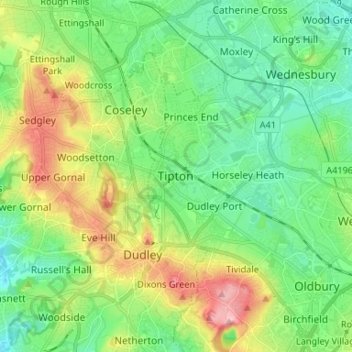
Naam: Topografische kaart Tipton, hoogte, reliëf.
Gemiddelde hoogte: 159 m
Minimale hoogte: 107 m
Maximale hoogte: 270 m
Andere topografische kaarten
Klik op een kaart om zijn topografie, zijn hoogte en zijn reliëf te bekijken.
Rowley Hills
United Kingdom > England > Sandwell > Tividale
The largest hill, Turner's Hill, is the highest point in the West Midlands county, with an altitude of 269 metres (883 ft) above sea level. Views from the summit include the Clee Hills, Clent Hills, Cannock Chase, and much of Birmingham and the Black Country. The height has also led to the construction of two…
Gemiddelde hoogte: 182 m
Causeway Green Park
United Kingdom > England > Sandwell > Causeway Green > The Ashes
Gemiddelde hoogte: 184 m