
Doe een donatie
Rust jezelf uit voor je volgende avontuur:
Als Amazon-partner verdient deze site een commissie op in aanmerking komende aankopen, zonder extra kosten voor jou.
Topografische kaart Round Rock
Klik op de kaart om de hoogte weer te geven.
Doe een donatie
Rust jezelf uit voor je volgende avontuur:
Als Amazon-partner verdient deze site een commissie op in aanmerking komende aankopen, zonder extra kosten voor jou.
Round Rock
The city straddles the Balcones Escarpment, a fault line in which the areas roughly east of Interstate 35 are flat and characterized by having black, fertile soils of the Blackland Prairie, and the west side of the Escarpment, which consists mostly of hilly, karst-like terrain with little topsoil and higher elevations and which is part of the Texas Hill Country. Located about 20 miles (32 km) north of downtown Austin, Round Rock shares a common border with Austin at Texas State Highway 45.
Doe een donatie
Rust jezelf uit voor je volgende avontuur:
Als Amazon-partner verdient deze site een commissie op in aanmerking komende aankopen, zonder extra kosten voor jou.
Over deze kaart
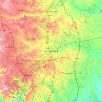
Naam: Topografische kaart Round Rock, hoogte, reliëf.
Locatie: Round Rock, Williamson County, Texas, 78680, United States (30.34859 -97.83881 30.66859 -97.51881)
Gemiddelde hoogte: 236 m
Minimale hoogte: 147 m
Maximale hoogte: 342 m
Doe een donatie
Rust jezelf uit voor je volgende avontuur:
Als Amazon-partner verdient deze site een commissie op in aanmerking komende aankopen, zonder extra kosten voor jou.