
Topografische kaart Simi Valley
Interactieve kaart
Klik op de kaart om de hoogte weer te geven.
Over deze kaart
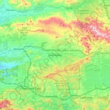
Naam: Topografische kaart Simi Valley, hoogte, reliëf.
Gemiddelde hoogte: 379 m
Minimale hoogte: 65 m
Maximale hoogte: 1.126 m
Andere topografische kaarten
Klik op een kaart om zijn topografie, zijn hoogte en zijn reliëf te bekijken.
Jasmine Glen Estates
United States > California > Ventura County > Simi Valley
Jasmine Glen Estates, Simi Valley, Ventura County, CAL Fire Southern Region, California, 90363, United States
Gemiddelde hoogte: 331 m
Strathearn
United States > California > Ventura County > Simi Valley
Strathearn, Simi Valley, Ventura County, CAL Fire Southern Region, California, 93065, United States
Gemiddelde hoogte: 261 m