
Topografische kaart Beaver Dam State Park
Interactieve kaart
Klik op de kaart om de hoogte weer te geven.
Over deze kaart
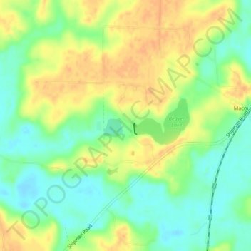
Naam: Topografische kaart Beaver Dam State Park, hoogte, reliëf.
Gemiddelde hoogte: 173 m
Minimale hoogte: 155 m
Maximale hoogte: 189 m
Andere topografische kaarten
Klik op een kaart om zijn topografie, zijn hoogte en zijn reliëf te bekijken.
Carlinville
United States > Illinois > Macoupin County
Carlinville, Macoupin County, Illinois, 62626, United States
Gemiddelde hoogte: 186 m
Virden
United States > Illinois > Macoupin County
Virden, Macoupin County, Illinois, 62690, United States
Gemiddelde hoogte: 202 m
Chesterfield
United States > Illinois > Macoupin County
Chesterfield, Macoupin County, Illinois, United States
Gemiddelde hoogte: 180 m
Medora
United States > Illinois > Macoupin County
Medora, Macoupin County, Illinois, United States
Gemiddelde hoogte: 184 m
Wilsonville
United States > Illinois > Macoupin County
Wilsonville, Macoupin County, Illinois, 62093, United States
Gemiddelde hoogte: 192 m
Bunker Hill
United States > Illinois > Macoupin County
Bunker Hill, Macoupin County, Illinois, 62014, United States
Gemiddelde hoogte: 193 m
Shipman
United States > Illinois > Macoupin County
Shipman, Macoupin County, Illinois, United States
Gemiddelde hoogte: 191 m