
Topografische kaart Deal Island
Interactieve kaart
Klik op de kaart om de hoogte weer te geven.
Over deze kaart
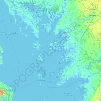
Naam: Topografische kaart Deal Island, hoogte, reliëf.
Locatie: Deal Island, Somerset County, Maryland, 21821, USA (37.82235 -76.26354 38.46235 -75.62354)
Gemiddelde hoogte: 2 m
Minimale hoogte: -4 m
Maximale hoogte: 32 m
Andere topografische kaarten
Klik op een kaart om zijn topografie, zijn hoogte en zijn reliëf te bekijken.
Severn River
USA > Maryland > Epping Forest
Severn River, Severn Road, Parole, Epping Forest, Anne Arundel County, Maryland, 21405, USA
Gemiddelde hoogte: 13 m
Kingsville
USA > Maryland > Kingsville
Kingsville, Baltimore County, Maryland, 21087, USA
Gemiddelde hoogte: 83 m
Henrys Bridge
USA > Maryland > Henrys Bridge
Henrys Bridge, Baltimore County, Maryland, 21131, USA
Gemiddelde hoogte: 165 m
Savage River
Savage River, Garrett County, Maryland, 21523, USA
Gemiddelde hoogte: 687 m
Grahams Green Acres
USA > Maryland > Grahams Green Acres
Grahams Green Acres, Carroll County, Maryland, 21776, USA
Gemiddelde hoogte: 223 m
Sue Island
Sue Island, Towson, Baltimore County, Maryland, 21220-5203, USA
Gemiddelde hoogte: 47 m
Swainson Island
Swainson Island, Cabin John, Montgomery County, Maryland, USA
Gemiddelde hoogte: 52 m
Sugarloaf Mountain
Sugarloaf Mountain, Frederick County, Maryland, 20842, USA
Gemiddelde hoogte: 200 m