
Topografische kaart North Wilton
Interactieve kaart
Klik op de kaart om de hoogte weer te geven.
Over deze kaart
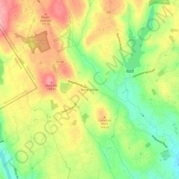
Naam: Topografische kaart North Wilton, hoogte, reliëf.
Gemiddelde hoogte: 138 m
Minimale hoogte: 75 m
Maximale hoogte: 199 m
Andere topografische kaarten
Klik op een kaart om zijn topografie, zijn hoogte en zijn reliëf te bekijken.
Cannondale
United States > Connecticut > Western Connecticut Planning Region > Wilton
Cannondale, Wilton, Western Connecticut Planning Region, Connecticut, 06897, United States
Gemiddelde hoogte: 110 m
Georgetown
United States > Connecticut > Western Connecticut Planning Region > Wilton
Georgetown, Wilton, Western Connecticut Planning Region, Connecticut, 06829, United States
Gemiddelde hoogte: 143 m
South Wilton
United States > Connecticut > Western Connecticut Planning Region > Wilton
South Wilton, Wilton, Western Connecticut Planning Region, Connecticut, 06851, United States
Gemiddelde hoogte: 70 m
Norwalk River
United States > Connecticut > Western Connecticut Planning Region > Wilton > Cannondale
Norwalk River, Cannondale, Wilton, Western Connecticut Planning Region, Connecticut, 06897, United States
Gemiddelde hoogte: 106 m