
Topografische kaart Dhanbad
Interactieve kaart
Klik op de kaart om de hoogte weer te geven.
Dhanbad
Dhanbad has an average elevation of 227 m (745 ft). Its geographical length (extending from north to south) is 15 miles (24 km) and the breadth (stretching across east to West) is 10 miles (16 km). It shares its boundaries with West Bengal in the eastern and southern part, Dumka and Giridih in the North and Bokaro District in the west. Dhanbad comes under the Chota Nagpur Plateau.
Over deze kaart
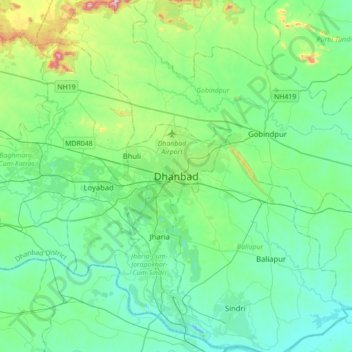
Naam: Topografische kaart Dhanbad, hoogte, reliëf.
Gemiddelde hoogte: 212 m
Minimale hoogte: 113 m
Maximale hoogte: 633 m