
Topografische kaart Ulen
Interactieve kaart
Klik op de kaart om de hoogte weer te geven.
Over deze kaart
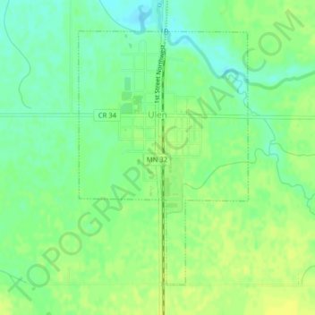
Naam: Topografische kaart Ulen, hoogte, reliëf.
Locatie: Ulen, Clay County, Minnesota, 56585, United States (47.06425 -96.26891 47.08599 -96.24753)
Gemiddelde hoogte: 352 m
Minimale hoogte: 342 m
Maximale hoogte: 359 m
Andere topografische kaarten
Klik op een kaart om zijn topografie, zijn hoogte en zijn reliëf te bekijken.
Dilworth
United States > Minnesota > Clay County
Dilworth, Clay County, Minnesota, 56529, United States
Gemiddelde hoogte: 278 m
Comstock
United States > Minnesota > Clay County
Comstock, Clay County, Minnesota, 56525, United States
Gemiddelde hoogte: 281 m
Hitterdal
United States > Minnesota > Clay County
Hitterdal, Clay County, Minnesota, United States
Gemiddelde hoogte: 379 m
Georgetown
United States > Minnesota > Clay County
Georgetown, Clay County, Minnesota, United States
Gemiddelde hoogte: 269 m
Baker
United States > Minnesota > Clay County
Baker, Clay County, Minnesota, United States
Gemiddelde hoogte: 286 m
Hitterdahl WMA
United States > Minnesota > Clay County
Hitterdahl WMA, 270th Street North, Clay County, Minnesota, 56552, United States
Gemiddelde hoogte: 379 m
Sabin
United States > Minnesota > Clay County
Sabin, Clay County, Minnesota, United States
Gemiddelde hoogte: 282 m
Glyndon
United States > Minnesota > Clay County
Glyndon, Clay County, Minnesota, 56547, United States
Gemiddelde hoogte: 282 m
Moorhead
United States > Minnesota > Clay County
Moorhead, Clay County, Minnesota, United States
Gemiddelde hoogte: 277 m
Kragnes
United States > Minnesota > Clay County
Kragnes, Clay County, Minnesota, United States
Gemiddelde hoogte: 273 m
Moorhead
United States > Minnesota > Clay County > Moorhead > Moorhead
Moorhead, Clay County, Minnesota, 56563, United States
Gemiddelde hoogte: 277 m
confluence of Red River of the North and Buffalo River
United States > Minnesota > Clay County
confluence of Red River of the North and Buffalo River, Wiser Township, Clay County, Minnesota, United States
Gemiddelde hoogte: 268 m
Barnesville
United States > Minnesota > Clay County
Barnesville, Clay County, Minnesota, 56514, United States
Gemiddelde hoogte: 311 m
Felton
United States > Minnesota > Clay County
Felton, Clay County, Minnesota, United States
Gemiddelde hoogte: 279 m
Hawley
United States > Minnesota > Clay County
Hawley, Clay County, Minnesota, United States
Gemiddelde hoogte: 356 m