
Topografische kaart Payún Matrú
Interactieve kaart
Klik op de kaart om de hoogte weer te geven.
Over deze kaart
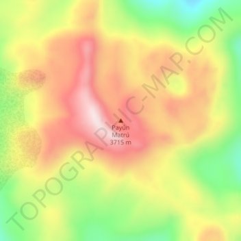
Naam: Topografische kaart Payún Matrú, hoogte, reliëf.
Gemiddelde hoogte: 3.462 m
Minimale hoogte: 3.222 m
Maximale hoogte: 3.665 m
Payún Matrú lies in the Malargüe Department of the Mendoza Province, in Argentina. The area is inhospitable due to the lack of usable water and high elevation. Nevertheless, there are many paved roads such as National Route 40 which passes west of the field, and National Route 186 which runs around its northern and eastern parts. The volcano is within the Reserva Provincial La Payunia. Owing to the variety of volcanic landforms, the province was included in the 2010 Tentative List of UNESCO World Heritage Sites and a number of potential geosites have been identified at Payún Matrú itself.