
Topografische kaart Airdrie
Interactieve kaart
Klik op de kaart om de hoogte weer te geven.
Over deze kaart
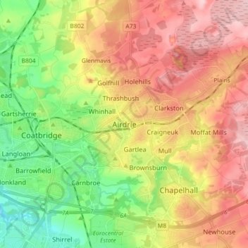
Naam: Topografische kaart Airdrie, hoogte, reliëf.
Locatie: Airdrie, North Lanarkshire, Scotland, ML6 6BU, United Kingdom (55.82578 -4.01959 55.90578 -3.93959)
Gemiddelde hoogte: 136 m
Minimale hoogte: 48 m
Maximale hoogte: 228 m
Airdrie's name first appeared in the Register of the Great Seal of Scotland (Registrum Magni Sigilii Regum Scotorum) in 1373 as Ardre. By 1546 it had become Ardry and by 1587 it was known as Ardrie. In 1630 it finally appeared in the Register as Airdrie. Given the topography of the area, the most likely interpretation is that the name derives from the Gaelic An Àrd Ruigh meaning a level height or high pasture land. Another possibility is that it is from the Gaelic An Àrd Àirighe meaning a sheiling, a summer pasture/shepherd's hut. A third possibility is the Gaelic Ard Reidh meaning a high plain. A further, non-Gaelic alternative is the Brythonic, i.e. Cumbric or North Welsh, ard tref (becoming ardre by process of assimilation), meaning a high steading or farmstead, which would date back to the times of the Kingdom of Strathclyde, before the expansion of Gaelic or English speech into the region. Airthrey Castle in Stirlingshire may have a similar derivation.
Andere topografische kaarten
Klik op een kaart om zijn topografie, zijn hoogte en zijn reliëf te bekijken.
Stepps
United Kingdom > Scotland > North Lanarkshire
Stepps, North Lanarkshire, Scotland, G33 6HB, United Kingdom
Gemiddelde hoogte: 73 m
Newmains
United Kingdom > Scotland > North Lanarkshire > Newmains
Newmains, North Lanarkshire, Scotland, ML2 9EY, United Kingdom
Gemiddelde hoogte: 163 m