
Topografische kaart Mount Katmai
Interactieve kaart
Klik op de kaart om de hoogte weer te geven.
Over deze kaart
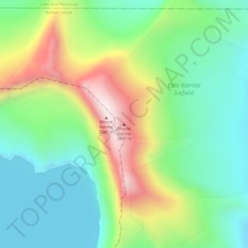
Naam: Topografische kaart Mount Katmai, hoogte, reliëf.
Locatie: Mount Katmai, Kodiak Island, Alaska, United States (58.27810 -154.94965 58.27820 -154.94955)
Gemiddelde hoogte: 1.507 m
Minimale hoogte: 1.269 m
Maximale hoogte: 1.968 m
Mount Katmai (Russian: Катмай) is a large stratovolcano (composite volcano) on the Alaska Peninsula in southern Alaska, located within Katmai National Park and Preserve. It is about 6.3 miles (10 km) in diameter with a central lake-filled caldera about two by three miles (3.2 by 4.8 km) in size, formed during the Novarupta eruption of 1912. The caldera rim reaches a maximum elevation of 6,716 feet (2,047 m). In 1975 the surface of the crater lake was at an elevation of about 4,220 feet (1,286 m), and the estimated elevation of the caldera floor is about 3,400 ft (1,040 m). The mountain is located in Kodiak Island Borough, very close to its border with Lake and Peninsula Borough.
Andere topografische kaarten
Klik op een kaart om zijn topografie, zijn hoogte en zijn reliëf te bekijken.
Raspberry Island
United States > Alaska > Kodiak Island
Raspberry Island, Kodiak Island, Alaska, United States
Gemiddelde hoogte: 71 m
Woody Island
United States > Alaska > Kodiak Island
Woody Island, Kodiak Island, Alaska, United States
Gemiddelde hoogte: 9 m
Trident Volcano
United States > Alaska > Kodiak Island
Trident Volcano, Kodiak Island, Alaska, United States
Gemiddelde hoogte: 1.338 m
Kodiak
United States > Alaska > Kodiak Island
Kodiak, Kodiak Island, Alaska, United States
Gemiddelde hoogte: 62 m