
Topografische kaart Port Townsend
Klik op de kaart om de hoogte weer te geven.
Over deze kaart
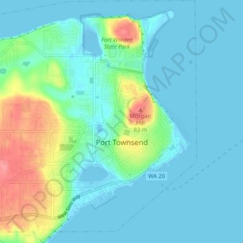
Naam: Topografische kaart Port Townsend, hoogte, reliëf.
Locatie: Port Townsend, Jefferson County, Washington, United States (48.09772 -122.81632 48.14630 -122.74714)
Gemiddelde hoogte: 19 m
Minimale hoogte: -7 m
Maximale hoogte: 90 m
Andere topografische kaarten
Klik op een kaart om zijn topografie, zijn hoogte en zijn reliëf te bekijken.
Mount Olympus
United States > Washington > Jefferson County
With notable local relief, Mount Olympus ascends over 2,100 m (6,900 ft) from the 293 m (961 ft) elevation confluence of the Hoh River with Glacier Creek in only 8.8 km (5.5 mi). Mount Olympus has 2,386 m (7,828 ft) of prominence, ranking 5th in the state of Washington.
Gemiddelde hoogte: 1.934 m