
Topografische kaart Valentine
Interactieve kaart
Klik op de kaart om de hoogte weer te geven.
Over deze kaart
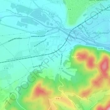
Naam: Topografische kaart Valentine, hoogte, reliëf.
Gemiddelde hoogte: 408 m
Minimale hoogte: 354 m
Maximale hoogte: 563 m
Andere topografische kaarten
Klik op een kaart om zijn topografie, zijn hoogte en zijn reliëf te bekijken.
Revel
France > Occitania > Haute-Garonne
Revel, Toulouse, Haute-Garonne, Occitania, Metropolitan France, 31250, France
Gemiddelde hoogte: 239 m
Mall Barrat
France > Occitania > Haute-Garonne > Castillon-de-Larboust
Mall Barrat, Castillon-de-Larboust, Saint-Gaudens, Haute-Garonne, Occitania, Metropolitan France, 31110, France
Gemiddelde hoogte: 2.542 m
Luchon-Superbagnères
France > Occitania > Haute-Garonne > Saint-Aventin > Luchon-Superbagnères
Luchon-Superbagnères, Saint-Aventin, Saint-Gaudens, Haute-Garonne, Occitania, Metropolitan France, 31110, France
Gemiddelde hoogte: 1.331 m
Bagnères-de-Luchon
France > Occitania > Haute-Garonne > Bagnères-de-Luchon
Bagnères-de-Luchon, Saint-Gaudens, Haute-Garonne, Occitania, Metropolitan France, 31110, France
Gemiddelde hoogte: 1.666 m