
Topografische kaart Mara River
Interactieve kaart
Klik op de kaart om de hoogte weer te geven.
Over deze kaart
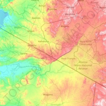
Naam: Topografische kaart Mara River, hoogte, reliëf.
Locatie: Mara River, Mara Region, Lake Zone, Tanzania (-1.60844 33.93529 -1.03747 35.24493)
Gemiddelde hoogte: 1.530 m
Minimale hoogte: 1.130 m
Maximale hoogte: 2.300 m
The altitudes in the basin range from 2,932 m around the sources in the Mau Escarpment to 1,134 m around Lake Victoria. The amount of precipitation varies according to these altitudes. The Mau Escarpment receives most rainfall with a mean annual rainfall between 1,000 and 1,750 mm. The transboundary middle savannah grasslands receive an average between 900 and 1,000 mm, and the Kenyan lower Loita hills and the area around Lake Victoria only about 700 and 850 mm rain per year. On top of this rainfall variability in space, the region is also known for its rainfall variability in time, which means that the different areas all receive variable amounts of rainfall over the year. The rainfall seasons are bi-modal, with the long rains starting in mid-March to June with a peak in April, while the short rains occur between September and December.[citation needed]
Andere topografische kaarten
Klik op een kaart om zijn topografie, zijn hoogte en zijn reliëf te bekijken.
Serengeti National Park
Serengeti National Park, Ikoma, Serengeti, Mara Region, Lake Zone, Tanzania
Gemiddelde hoogte: 1.524 m
Murangi
Murangi, Musoma, Mara Region, Lake Zone, Tanzania
Gemiddelde hoogte: 1.143 m
Musoma
Musoma, Musoma Municipal, Mara Region, Lake Zone, 31100, Tanzania
Gemiddelde hoogte: 1.180 m