
Doe een donatie
Rust jezelf uit voor je volgende avontuur:
Als Amazon-partner verdient deze site een commissie op in aanmerking komende aankopen, zonder extra kosten voor jou.
Topografische kaart Stone Mountain
Klik op de kaart om de hoogte weer te geven.
Doe een donatie
Rust jezelf uit voor je volgende avontuur:
Als Amazon-partner verdient deze site een commissie op in aanmerking komende aankopen, zonder extra kosten voor jou.
Stone Mountain
The park is owned by the state of Georgia. At its summit, the elevation is 1,686 feet (514 m) above sea level and 825 feet (251 m) above the surrounding area. Stone Mountain is well known for not only its geology, but also the enormous rock relief on its north face, the largest bas-relief artwork in the world. The carving, completed in 1972, depicts three Confederate leaders, Jefferson Davis, Robert E. Lee, and Stonewall Jackson.
Doe een donatie
Rust jezelf uit voor je volgende avontuur:
Als Amazon-partner verdient deze site een commissie op in aanmerking komende aankopen, zonder extra kosten voor jou.
Over deze kaart
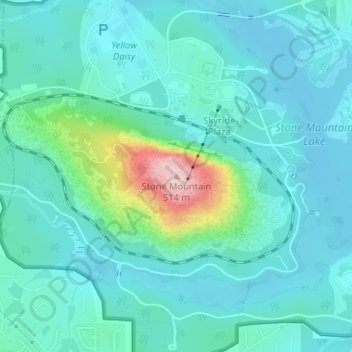
Naam: Topografische kaart Stone Mountain, hoogte, reliëf.
Locatie: Stone Mountain, DeKalb County, Georgia, 30087, United States (33.80617 -84.14580 33.80627 -84.14570)
Gemiddelde hoogte: 299 m
Minimale hoogte: 254 m
Maximale hoogte: 513 m
Doe een donatie
Rust jezelf uit voor je volgende avontuur:
Als Amazon-partner verdient deze site een commissie op in aanmerking komende aankopen, zonder extra kosten voor jou.
Andere topografische kaarten
Klik op een kaart om zijn topografie, zijn hoogte en zijn reliëf te bekijken.
Doe een donatie
Rust jezelf uit voor je volgende avontuur:
Als Amazon-partner verdient deze site een commissie op in aanmerking komende aankopen, zonder extra kosten voor jou.
Tucker
United States > Georgia > DeKalb County
Tucker, at 1,117 feet (340 m) feet above sea level, is the highest point of elevation on the railroad line between Atlanta and Richmond, Virginia.
Gemiddelde hoogte: 307 m
Doe een donatie
Rust jezelf uit voor je volgende avontuur:
Als Amazon-partner verdient deze site een commissie op in aanmerking komende aankopen, zonder extra kosten voor jou.
Doe een donatie
Rust jezelf uit voor je volgende avontuur:
Als Amazon-partner verdient deze site een commissie op in aanmerking komende aankopen, zonder extra kosten voor jou.
Tucker
United States > Georgia > DeKalb County > Tucker
Tucker, at 1,117 feet (340 m) feet above sea level, is the highest point of elevation on the railroad line between Atlanta and Richmond, Virginia.
Gemiddelde hoogte: 317 m
Tucker
United States > Georgia > DeKalb County
Tucker, at 1,117 feet (340 m) above sea level, is the highest point of elevation on the railroad line between Atlanta and Richmond, Virginia.
Gemiddelde hoogte: 307 m
Doe een donatie
Rust jezelf uit voor je volgende avontuur:
Als Amazon-partner verdient deze site een commissie op in aanmerking komende aankopen, zonder extra kosten voor jou.
Doe een donatie
Rust jezelf uit voor je volgende avontuur:
Als Amazon-partner verdient deze site een commissie op in aanmerking komende aankopen, zonder extra kosten voor jou.
Doe een donatie
Rust jezelf uit voor je volgende avontuur:
Als Amazon-partner verdient deze site een commissie op in aanmerking komende aankopen, zonder extra kosten voor jou.