
Topografische kaart Friendswood
Interactieve kaart
Klik op de kaart om de hoogte weer te geven.
Over deze kaart
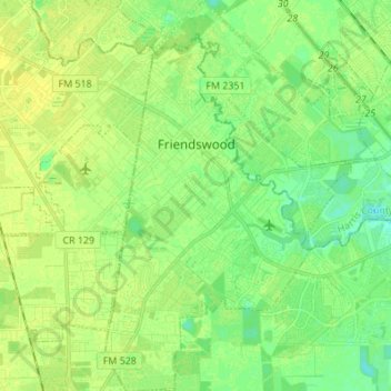
Naam: Topografische kaart Friendswood, hoogte, reliëf.
Locatie: Friendswood, Galveston County, Texas, 77546, United States (29.45406 -95.23308 29.57296 -95.14692)
Gemiddelde hoogte: 11 m
Minimale hoogte: 2 m
Maximale hoogte: 17 m
Andere topografische kaarten
Klik op een kaart om zijn topografie, zijn hoogte en zijn reliëf te bekijken.
Texas City
United States > Texas > Galveston County
Texas City, Galveston County, Texas, United States
Gemiddelde hoogte: 2 m
Nadeau
United States > Texas > Galveston County > Texas City
Nadeau, Texas City, Galveston County, Texas, 77590, United States
Gemiddelde hoogte: 4 m
Max's Creek
United States > Texas > Galveston County > Friendswood
Max's Creek, West Ranch, Friendswood, Galveston County, Texas, United States
Gemiddelde hoogte: 10 m
Dickinson
United States > Texas > Galveston County
Dickinson, Galveston County, Texas, 77539, United States
Gemiddelde hoogte: 6 m
League City
United States > Texas > Galveston County > League City > League City
League City, Galveston County, Texas, 77573, United States
Gemiddelde hoogte: 7 m
League City
United States > Texas > Galveston County
League City, Galveston County, Texas, 77573, United States
Gemiddelde hoogte: 7 m
Kemah
United States > Texas > Galveston County > Kemah
Kemah, Galveston County, Texas, United States
Gemiddelde hoogte: 5 m
Galveston
United States > Texas > Galveston County > Galveston
Galveston, Galveston County, Texas, 77553, United States
Gemiddelde hoogte: 1 m
Galveston
United States > Texas > Galveston County
Galveston, Galveston County, Texas, United States
Gemiddelde hoogte: 1 m