
Topografische kaart Georgetown
Klik op de kaart om de hoogte weer te geven.
Georgetown
The city is located on the northeastern edge of Texas Hill Country. Portions of Georgetown are located on either side of the Balcones Escarpment, a fault line in which the areas roughly east of IH-35 are flat and characterized by having black, fertile soils of the Blackland Prairie, and the west side of the escarpment which consists mostly of hilly, karst-like terrain with little topsoil and higher elevations and which is part of the Texas Hill Country. Inner Space Cavern, a large cave, is a major tourist attraction found on the south side of the city, just west of Interstate 35, and is a large-scale example of limestone karst formations.
Over deze kaart
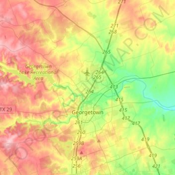
Naam: Topografische kaart Georgetown, hoogte, reliëf.
Locatie: Georgetown, Williamson County, Texas, 78626, United States (30.57080 -97.83279 30.75254 -97.58988)
Gemiddelde hoogte: 247 m
Minimale hoogte: 178 m
Maximale hoogte: 322 m
Andere topografische kaarten
Klik op een kaart om zijn topografie, zijn hoogte en zijn reliëf te bekijken.
Georgetown
United States > Texas > Williamson County > Georgetown
The city is located on the northeastern edge of Texas Hill Country. Portions of Georgetown are located on either side of the Balcones Escarpment, a fault line in which the areas roughly east of IH-35 are flat and characterized by having black, fertile soils of the Blackland Prairie, and the west side of the…
Gemiddelde hoogte: 228 m
Soil Conservation Service Site 12 Dam
United States > Texas > Williamson County > Type
Gemiddelde hoogte: 173 m
Soil Conservation Service Site 12 Dam
United States > Texas > Williamson County > Type
Gemiddelde hoogte: 173 m
Soil Conservation Service Site 12 Dam
United States > Texas > Williamson County > Type
Gemiddelde hoogte: 173 m