
Topografische kaart Kampung Janda Baik
Interactieve kaart
Klik op de kaart om de hoogte weer te geven.
Over deze kaart
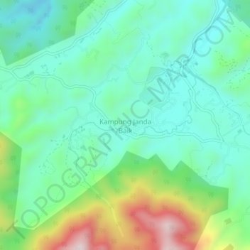
Naam: Topografische kaart Kampung Janda Baik, hoogte, reliëf.
Locatie: Kampung Janda Baik, Bentong, Pahang, 28750, Malaysia (3.30276 101.82868 3.34276 101.86868)
Gemiddelde hoogte: 501 m
Minimale hoogte: 351 m
Maximale hoogte: 895 m
Before Janda Baik was founded in 1930, the area was primarily inhabited by Orang Asli tribes. The village was founded when some residents moved from Bentong to an area with a higher elevation due to the 1926 floods that affected Bentong and other low elevation areas. The earliest founders for this village are Haji Deris, Haji Kadir, and Haji Yasir, who built a hut and stayed in the area for almost a week before others start to populate the area. The village was originally given the name Kampung Tiga Haji to refer to the three early settlers.
Andere topografische kaarten
Klik op een kaart om zijn topografie, zijn hoogte en zijn reliëf te bekijken.
Kampung Chamang
Kampung Chamang, Bentong, Pahang, 29700, Malaysia
Gemiddelde hoogte: 164 m
Kampung Perting
Kampung Perting, Bentong, Pahang, 29700, Malaysia
Gemiddelde hoogte: 154 m
Bukit Raka
Bukit Raka, Bentong, Pahang, 29700, Malaysia
Gemiddelde hoogte: 251 m
Sungai Benus
Sungai Benus, Bentong, Pahang, Malaysia
Gemiddelde hoogte: 512 m
Kampung Benus
Kampung Benus, Bentong, Pahang, 28700, Malaysia
Gemiddelde hoogte: 132 m
Sungai Benus
Sungai Benus, Bentong, Pahang, Malaysia
Gemiddelde hoogte: 452 m
Sungai Kelau
Sungai Kelau, Bentong, Pahang, 28600, Malaysia
Gemiddelde hoogte: 72 m
Jeriau Waterfall
Jeriau Waterfall, Bentong, Pahang, Malaysia
Gemiddelde hoogte: 1.073 m
Sg. Dua Fall
Sg. Dua Fall, Bentong, Pahang, Malaysia
Gemiddelde hoogte: 217 m