
Topografische kaart Aughavas
Interactieve kaart
Klik op de kaart om de hoogte weer te geven.
Over deze kaart
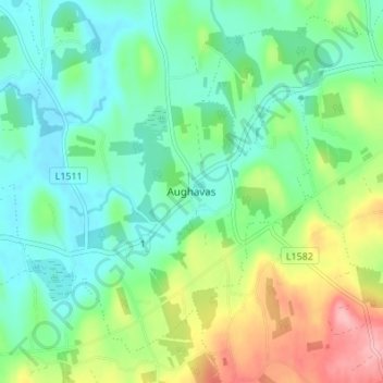
Naam: Topografische kaart Aughavas, hoogte, reliëf.
Gemiddelde hoogte: 93 m
Minimale hoogte: 55 m
Maximale hoogte: 179 m
Andere topografische kaarten
Klik op een kaart om zijn topografie, zijn hoogte en zijn reliëf te bekijken.
Mohill
Mohill, Mohill ED, Carrick-on-Shannon Municipal District, County Leitrim, Connacht, N41 R9T3, Ireland
Gemiddelde hoogte: 60 m
Carrick-on-Shannon
Carrick-on-Shannon, County Leitrim, Connacht, Ireland
Gemiddelde hoogte: 48 m
Corlea
Corlea, Drumsna ED, Carrick-on-Shannon Municipal District, County Leitrim, Connacht, Ireland
Gemiddelde hoogte: 70 m
Leitrim
Leitrim, Kiltubbrid ED, Ballinamore Municipal District, County Leitrim, Connacht, Ireland
Gemiddelde hoogte: 73 m
Carrick-on-Shannon Municipal District
Carrick-on-Shannon Municipal District, County Leitrim, Connacht, Ireland
Gemiddelde hoogte: 63 m
Cloone
Ireland > County Leitrim > Cloone
Cloone, Ballinamore Municipal District, County Leitrim, Connacht, Ireland
Gemiddelde hoogte: 65 m
Cleendargan
Cleendargan, Garadice ED, Ballinamore Municipal District, County Leitrim, Connacht, Ireland
Gemiddelde hoogte: 78 m
Drumkeeran
Ireland > County Leitrim > Drumkeeran
Drumkeeran, Manorhamilton Municipal District, County Leitrim, Connacht, Ireland
Gemiddelde hoogte: 103 m