
Topografische kaart Albertville
Interactieve kaart
Klik op de kaart om de hoogte weer te geven.
Albertville
The city sits at an elevation of 1,060 feet (320 m) atop Sand Mountain, a plateau that in this area is about 15 miles (24 km) wide. The Tennessee Valley Divide passes through the southern part of the city. The majority of the city drains north to Short Creek, a tributary of the Tennessee River, while the southern part drains to Slab Creek, a west-flowing tributary of the Locust Fork of the Black Warrior River. The current slogan of Albertville is "The Heart of Sand Mountain", which can be seen on the welcome sign coming into the city.
Over deze kaart
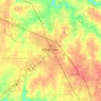
Naam: Topografische kaart Albertville, hoogte, reliëf.
Locatie: Albertville, Marshall County, Alabama, 35950, United States (34.21637 -86.27448 34.31681 -86.14596)
Gemiddelde hoogte: 309 m
Minimale hoogte: 254 m
Maximale hoogte: 356 m
Andere topografische kaarten
Klik op een kaart om zijn topografie, zijn hoogte en zijn reliëf te bekijken.