
Topografische kaart Rio Grande City
Interactieve kaart
Klik op de kaart om de hoogte weer te geven.
Over deze kaart
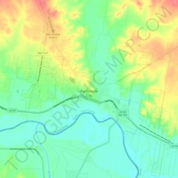
Naam: Topografische kaart Rio Grande City, hoogte, reliëf.
Locatie: Rio Grande City, Starr County, Texas, United States (26.33226 -98.86869 26.43818 -98.76983)
Gemiddelde hoogte: 63 m
Minimale hoogte: 40 m
Maximale hoogte: 102 m
Andere topografische kaarten
Klik op een kaart om zijn topografie, zijn hoogte en zijn reliëf te bekijken.
Fronton Island
United States > Texas > Starr County
Fronton Island, Starr County, Texas, United States
Gemiddelde hoogte: 102 m
Rio Grande
United States > Texas > Starr County
Rio Grande, Starr County, Texas, United States
Gemiddelde hoogte: 71 m
Roma
United States > Texas > Starr County
Roma, Starr County, Texas, United States
Gemiddelde hoogte: 73 m
Rio Grande
United States > Texas > Starr County > Roma > Campobello Colonia
Rio Grande, De La Cruz Colonia, Campobello Colonia, Roma, Starr County, Texas, 78584, United States
Gemiddelde hoogte: 63 m
Garza-Gutierrez Colonia
United States > Texas > Starr County > Rio Grande City > Garza-Gutierrez Colonia
Garza-Gutierrez Colonia, Rio Grande City, Starr County, Texas, United States
Gemiddelde hoogte: 59 m
Roma
United States > Texas > Starr County > Roma > Roma
Roma, Starr County, Texas, 78584, United States
Gemiddelde hoogte: 68 m
Rio Grande City
United States > Texas > Starr County > Rio Grande City > Rio Grande City
Rio Grande City, Starr County, Texas, United States
Gemiddelde hoogte: 60 m