
Topografische kaart Edson
Interactieve kaart
Klik op de kaart om de hoogte weer te geven.
Over deze kaart
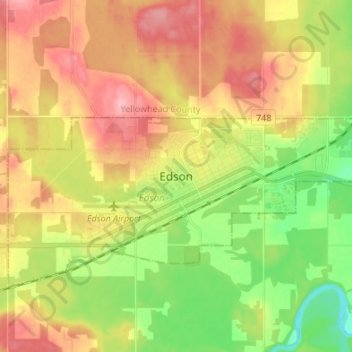
Naam: Topografische kaart Edson, hoogte, reliëf.
Locatie: Edson, Town of Edson, Alberta, T7E 1H7, Canada (53.54587 -116.48285 53.62587 -116.40285)
Gemiddelde hoogte: 928 m
Minimale hoogte: 868 m
Maximale hoogte: 988 m
Due to Edson's high elevation, the community experiences a subarctic climate (Köppen climate classification Dfc). The highest temperature ever recorded in Edson was 37.2 °C (99 °F) on 2 July 1924. The coldest temperature ever recorded was −48.3 °C (−55 °F) on 22 January 1943, and 14 January 1950.