
Topografische kaart Alta Vista
Interactieve kaart
Klik op de kaart om de hoogte weer te geven.
Over deze kaart
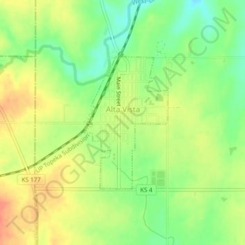
Naam: Topografische kaart Alta Vista, hoogte, reliëf.
Locatie: Alta Vista, Wabaunsee County, Kansas, United States (38.85509 -96.49469 38.86970 -96.48283)
Gemiddelde hoogte: 443 m
Minimale hoogte: 418 m
Maximale hoogte: 465 m
Alta Vista was founded in 1887, and it was incorporated as a city in 1905. Alta Vista is derived from the Spanish word for "high view", and the city was so named from its lofty elevation.
Andere topografische kaarten
Klik op een kaart om zijn topografie, zijn hoogte en zijn reliëf te bekijken.
McFarland
United States > Kansas > Wabaunsee County
McFarland, Wabaunsee County, Kansas, 66501, United States
Gemiddelde hoogte: 320 m
Maple Hill
United States > Kansas > Wabaunsee County
Maple Hill, Wabaunsee County, Kansas, United States
Gemiddelde hoogte: 298 m
Paxico
United States > Kansas > Wabaunsee County
Paxico, Wabaunsee County, Kansas, 66526, United States
Gemiddelde hoogte: 310 m
Volland
United States > Kansas > Wabaunsee County
Volland, Wabaunsee County, Kansas, United States
Gemiddelde hoogte: 387 m
Eskridge
United States > Kansas > Wabaunsee County
Eskridge, Wabaunsee County, Kansas, United States
Gemiddelde hoogte: 437 m
Mount Mitchell Heritage Prairie Park
United States > Kansas > Wabaunsee County > Wamego
Mount Mitchell Heritage Prairie Park, 29377, Mitchell Prairie Lane, Wamego, Wabaunsee County, Kansas, 66547, United States
Gemiddelde hoogte: 325 m
Harveyville
United States > Kansas > Wabaunsee County > Harveyville
Harveyville, Wabaunsee County, Kansas, United States
Gemiddelde hoogte: 351 m
Alma
United States > Kansas > Wabaunsee County
Alma, Wabaunsee County, Kansas, United States
Gemiddelde hoogte: 334 m