
Topografische kaart Yakushima
Interactieve kaart
Klik op de kaart om de hoogte weer te geven.
Over deze kaart
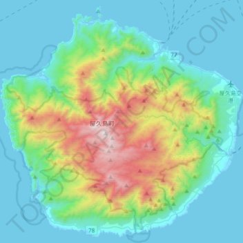
Naam: Topografische kaart Yakushima, hoogte, reliëf.
Locatie: Yakushima, Kumage County, Kagoshima Prefecture, Japan (30.22634 130.37636 30.46950 130.67177)
Gemiddelde hoogte: 401 m
Minimale hoogte: -2 m
Maximale hoogte: 1.904 m
The bedrock of the island is granite, and as such it hosts no active volcanoes. It has an area of approximately 504.5 square kilometres (194.8 sq mi). The island is roughly circular in shape, with a circumference of 89 kilometres (55 mi) and a diameter of 28 kilometres (17 mi). The highest elevations on the island are Miyanouradake (宮之浦岳), with a height of 1,935 metres (6,348 ft), and Nagatadake (永田岳), with a height of 1,886 metres (6,188 ft) above sea level; however, Yakushima has another 30 peaks of over 1,000 metres (3,300 ft) in height. There are numerous hot springs on the island.