
Topografische kaart Xochimilco
Interactieve kaart
Klik op de kaart om de hoogte weer te geven.
Xochimilco
Much of the borough's land is former lakebed. Its main elevations include Xochitepec and Tlacualleli mountains along with two volcanoes named Teutli and Tzompol. It contains two natural rivers called Santiago and Tepapantla along with the various canals, which is what is left of the lake. The elevated areas of the borough contain small forests of ocotes, strawberry trees, cedars, Montezuma cypress and a tree called a “tepozan.”
Over deze kaart
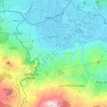
Naam: Topografische kaart Xochimilco, hoogte, reliëf.
Locatie: Xochimilco, Mexico City, Mexico (19.15254 -99.15439 19.32045 -99.00704)
Gemiddelde hoogte: 2.513 m
Minimale hoogte: 2.230 m
Maximale hoogte: 3.495 m
Andere topografische kaarten
Klik op een kaart om zijn topografie, zijn hoogte en zijn reliëf te bekijken.
Mexico City
Mexico > Mexico City > Mexico City
Mexico City is located in the Valley of Mexico, sometimes called the Basin of Mexico. This valley is located in the Trans-Mexican Volcanic Belt in the high plateaus of south-central Mexico. It has a minimum altitude of 2,200 meters (7,200 feet) above sea level and is surrounded by mountains and volcanoes that…
Gemiddelde hoogte: 2.321 m