
Topografische kaart Gangtok
Interactieve kaart
Klik op de kaart om de hoogte weer te geven.
Over deze kaart
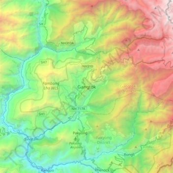
Naam: Topografische kaart Gangtok, hoogte, reliëf.
Locatie: Gangtok, Gangtok District, Sikkim, 737101, India (27.16905 88.45227 27.48905 88.77227)
Gemiddelde hoogte: 1.911 m
Minimale hoogte: 283 m
Maximale hoogte: 5.193 m
Gangtok (Sikkimese: [ɡaŋt̪ʰòk]) is a city, municipality, the capital and the most populous city of the Indian state of Sikkim and also the headquarters of Gangtok District. Gangtok is in the eastern Himalayan range, at an elevation of 1,650 m (5,410 ft). The city's population of 100,000 consists of the three Sikkimese ethnicities the Bhutias, Lepchas, Gorkhalis and also plainsmen from other states of India have settled here. Within the higher peaks of the Himalayas and with a year-round mild temperate climate, Gangtok is at the centre of Sikkim's tourism industry.
Andere topografische kaarten
Klik op een kaart om zijn topografie, zijn hoogte en zijn reliëf te bekijken.
Western Sikkim Subsection
India > Sikkim > Chungthang
Western Sikkim Subsection, Chungthang, Mangan District, Sikkim, 737120, India
Gemiddelde hoogte: 3.896 m
West District
West District, West Sikkim District, Sikkim, 737111, India
Gemiddelde hoogte: 2.636 m