
Topografische kaart Pau
Interactieve kaart
Klik op de kaart om de hoogte weer te geven.
Over deze kaart
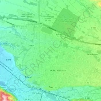
Naam: Topografische kaart Pau, hoogte, reliëf.
Gemiddelde hoogte: 205 m
Minimale hoogte: 159 m
Maximale hoogte: 341 m
The city, located at an average altitude of 200 metres (660 ft), is crossed by the Gave de Pau, where a ford gave passage to the Pyrenees. Gave is the name given to a torrent in the Pyrenees. The Gave de Pau, which becomes a torrent when mountain snow melts, takes its source in the Cirque de Gavarnie and is the main tributary of the Adour, into which it empties after 175 kilometres (109 mi). The crossing was used for pasturage for sheep in the high meadows. The old route is now a hiking path, GR 65, that runs 60 km (37 mi) south to the border.
Andere topografische kaarten
Klik op een kaart om zijn topografie, zijn hoogte en zijn reliëf te bekijken.
Urt
France > Nouvelle-Aquitaine > Pyrénées-Atlantiques
Urt, Bayonne, Pyrénées-Atlantiques, Nouvelle-Aquitaine, Metropolitan France, 64240, France
Gemiddelde hoogte: 29 m
Asson
France > Nouvelle-Aquitaine > Pyrénées-Atlantiques
Asson, Pau, Pyrénées-Atlantiques, Nouvelle-Aquitaine, Metropolitan France, 64800, France
Gemiddelde hoogte: 625 m
Montaut
France > Nouvelle-Aquitaine > Pyrénées-Atlantiques
Montaut, Pau, Pyrénées-Atlantiques, Nouvelle-Aquitaine, Metropolitan France, 64800, France
Gemiddelde hoogte: 360 m
Bayonne
France > Nouvelle-Aquitaine > Pyrénées-Atlantiques
Bayonne, Pyrénées-Atlantiques, Nouvelle-Aquitaine, Metropolitan France, 64100, France
Gemiddelde hoogte: 23 m