
Topografische kaart Paradise
Interactieve kaart
Klik op de kaart om de hoogte weer te geven.
Over deze kaart
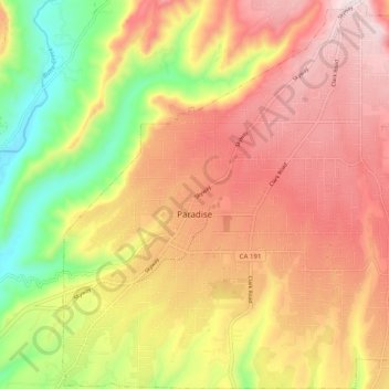
Naam: Topografische kaart Paradise, hoogte, reliëf.
Locatie: Paradise, Butte County, California, 95969, United States (39.72536 -121.65565 39.80154 -121.56445)
Gemiddelde hoogte: 464 m
Minimale hoogte: 139 m
Maximale hoogte: 726 m
The town is spread out on a wide ridge between deep canyons formed by the west branch of the Feather River to the east and Butte Creek to the west. The Paradise area extends northward to include the unincorporated town of Magalia, as well as Stirling City, eleven miles (18 km) north. Elevation of the area where the town is located is 1,778 feet (542 m). The town itself is approximately eight miles (13 km) east of the city of Chico, and ten miles (16 km) north of the Oroville area.
Andere topografische kaarten
Klik op een kaart om zijn topografie, zijn hoogte en zijn reliëf te bekijken.
Chico
United States > California > Butte County
Chico, Butte County, California, United States
Gemiddelde hoogte: 94 m
Jonesville
United States > California > Butte County
Jonesville, Butte County, CAL Fire Northern Region, California, United States
Gemiddelde hoogte: 1.663 m
Big Bend
United States > California > Butte County
Big Bend, Butte County, CAL Fire Northern Region, California, United States
Gemiddelde hoogte: 574 m
Parkhill
United States > California > Butte County
Parkhill, Butte County, CAL Fire Northern Region, California, United States
Gemiddelde hoogte: 599 m