
Topografische kaart Silverton
Interactieve kaart
Klik op de kaart om de hoogte weer te geven.
Over deze kaart
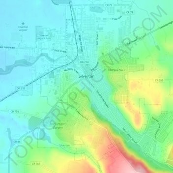
Naam: Topografische kaart Silverton, hoogte, reliëf.
Locatie: Silverton, Marion County, Oregon, 97381, United States (44.98185 -122.80381 45.02299 -122.75129)
Gemiddelde hoogte: 103 m
Minimale hoogte: 57 m
Maximale hoogte: 229 m
Silverton's elevation is between 200 and 250 feet (61 and 76 m) above mean sea level with the steep-sided, heavily-wooded Waldo Hills to the south rising an additional 200 feet (61 m). The agricultural richness of the environs is due to massive and repeated floods from prehistoric Lake Missoula in western Montana. Beginning approximately 13,000 years before the present, repeated flooding from Lake Missoula scoured eastern Washington and Oregon, carved out the Columbia River Gorge, and periodically swept down the Columbia River; when floodwaters met ice jams in southwest Washington, the backed-up water spilled over and filled the entire Willamette Valley to a depth of 300 to 400 feet (91 to 122 m) above current sea level, creating a body of water known as Lake Allison. The gradual receding of Lake Allison's waters left layered sedimentary volcanic and glacial soils to a height of about 180 to 200 feet (55 to 61 m) above current sea level throughout the Tualatin, Yamhill and Willamette Valleys.
Andere topografische kaarten
Klik op een kaart om zijn topografie, zijn hoogte en zijn reliëf te bekijken.
Aurora
United States > Oregon > Marion County
Aurora, Marion County, Oregon, United States
Gemiddelde hoogte: 43 m
Butteville
United States > Oregon > Marion County > Butteville
Butteville, Marion County, Oregon, United States
Gemiddelde hoogte: 53 m
Sam Brown Creek
United States > Oregon > Marion County
Sam Brown Creek, Marion County, Oregon, 97026, United States
Gemiddelde hoogte: 49 m
Salem
United States > Oregon > Marion County
Salem, Marion County, Oregon, United States
Gemiddelde hoogte: 96 m