
Topografische kaart Corregidor Island
Interactieve kaart
Klik op de kaart om de hoogte weer te geven.
Over deze kaart
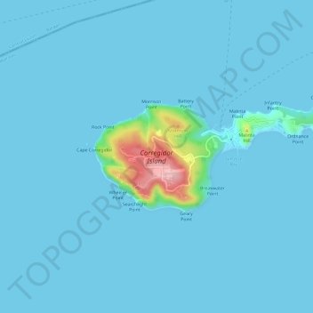
Naam: Topografische kaart Corregidor Island, hoogte, reliëf.
Gemiddelde hoogte: 11 m
Minimale hoogte: -1 m
Maximale hoogte: 180 m
The tadpole-shaped island, with its tail running eastward, is about 6.5 km (4.0 mi) long, about 2.0 km (1.2 mi) wide at its widest with a total land area of about 900 hectares (2,200 acres). The highest elevation is at 180 m (590 ft) on the Topside. The island is divided into four sections:
Andere topografische kaarten
Klik op een kaart om zijn topografie, zijn hoogte en zijn reliëf te bekijken.
La Monja Island
Philippines > Cavite > Cavite City
La Monja Island, Cavite City, Cavite, Calabarzon, 4100, Philippines
Gemiddelde hoogte: 0 m
Santa Amalia Rock
Philippines > Cavite > Cavite City
Santa Amalia Rock, Cavite City, Cavite, Calabarzon, 4100, Philippines
Gemiddelde hoogte: 67 m