
Topografische kaart Eibar
Interactieve kaart
Klik op de kaart om de hoogte weer te geven.
Over deze kaart
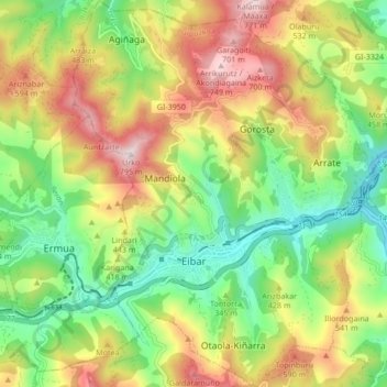
Naam: Topografische kaart Eibar, hoogte, reliëf.
Gemiddelde hoogte: 367 m
Minimale hoogte: 74 m
Maximale hoogte: 768 m
Eibar lies at an altitude of 121m above sea level, in the west of the province of Gipuzkoa, right next to Biscay. Eibar has an oceanic climate. The town lies in a narrow valley in a mountainous area, the highest mountains are between 700 and 800 metres high. Eibar is traversed by river Ego, which is a tributary of the Deba.
Andere topografische kaarten
Klik op een kaart om zijn topografie, zijn hoogte en zijn reliëf te bekijken.
Karakate
Spain > Autonomous Community of the Basque Country > Debabarrena > Soraluze
Karakate, Soraluze, Debabarrena, Gipuzkoa, Autonomous Community of the Basque Country, 20590, Spain
Gemiddelde hoogte: 366 m
Elgoibar
Spain > Autonomous Community of the Basque Country > Debabarrena > Elgoibar
Elgoibar, Debabarrena, Gipuzkoa, Autonomous Community of the Basque Country, Spain
Gemiddelde hoogte: 321 m