
Topografische kaart Buji Sub-district
Interactieve kaart
Klik op de kaart om de hoogte weer te geven.
Over deze kaart
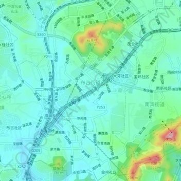
Naam: Topografische kaart Buji Sub-district, hoogte, reliëf.
Gemiddelde hoogte: 61 m
Minimale hoogte: 16 m
Maximale hoogte: 239 m
Andere topografische kaarten
Klik op een kaart om zijn topografie, zijn hoogte en zijn reliëf te bekijken.
Bantian Sub-district
China > Guangdong Province > Longgang District > Bantian Sub-district
Bantian Sub-district, Longgang District, Shenzhen, Guangdong Province, 518100, China
Gemiddelde hoogte: 96 m