
Topografische kaart Larzey
Interactieve kaart
Klik op de kaart om de hoogte weer te geven.
Over deze kaart
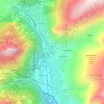
Naam: Topografische kaart Larzey, hoogte, reliëf.
Locatie: Larzey, Courmayeur, Aosta Valley, 11013, Italy (45.77887 6.95038 45.81887 6.99038)
Gemiddelde hoogte: 1.596 m
Minimale hoogte: 1.095 m
Maximale hoogte: 2.320 m
Andere topografische kaarten
Klik op een kaart om zijn topografie, zijn hoogte en zijn reliëf te bekijken.
Mont Blanc - Monte Bianco
Italy > Aosta Valley > Courmayeur
Mont Blanc - Monte Bianco, Sentiero per Rifugio Monzino, Courmayeur, Aosta Valley, Italy
Gemiddelde hoogte: 4.092 m
Val Veny
Italy > Aosta Valley > Courmayeur
Val Veny, Courmayeur, Aosta Valley, Italy
Gemiddelde hoogte: 2.151 m
Ghiacciaio del Miage
Italy > Aosta Valley > Courmayeur
Ghiacciaio del Miage, Sentiero 15 Rifugio Gonella, Courmayeur, Aosta Valley, Italy
Gemiddelde hoogte: 2.911 m