
Topografische kaart Carlsbad
Interactieve kaart
Klik op de kaart om de hoogte weer te geven.
Over deze kaart
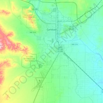
Naam: Topografische kaart Carlsbad, hoogte, reliëf.
Locatie: Carlsbad, Eddy County, New Mexico, 88220, United States (32.29829 -104.28964 32.47653 -104.13431)
Gemiddelde hoogte: 983 m
Minimale hoogte: 925 m
Maximale hoogte: 1.159 m
Carlsbad is located near the center of Eddy County at 32°24′43″N 104°14′11″W / 32.41194°N 104.23639°W / 32.41194; -104.23639 (32.407577, -104.245167) at an elevation of 3,295 feet (1,004 m). Carlsbad is situated in the northern reaches of the Chihuahuan Desert ecoregion, in the lower Pecos River Valley. Via US 285 it is 36 miles (58 km) north to Artesia and 86 miles (138 km) south to Pecos, Texas. US Routes 62 and 180 lead northeast 69 miles (111 km) to Hobbs and southwest 169 miles (272 km) to El Paso.
Andere topografische kaarten
Klik op een kaart om zijn topografie, zijn hoogte en zijn reliëf te bekijken.
Tecolote Peak
United States > New Mexico > Eddy County
Tecolote Peak, Eddy County, New Mexico, United States
Gemiddelde hoogte: 968 m
Carlsbad Cavern
United States > New Mexico > Eddy County
Carlsbad Cavern, Natural Entrance Path, Eddy County, New Mexico, United States
Gemiddelde hoogte: 1.274 m