
Topografische kaart Aurora
Interactieve kaart
Klik op de kaart om de hoogte weer te geven.
Aurora
Aurora's official elevation, posted on signs at the city limits, is 5,471 feet (1,668 m). However, the city spans a difference in elevation of nearly 1,000 feet (300 m). The lowest elevation of 5,285 feet (1,611 m) is found at the point where Sand Creek crosses the city limit in the northwest corner of the city, while the highest elevation of 6,229 feet (1,899 m) is on the extreme southern border of the city in Douglas County, near the intersection of Inspiration and Gartrell roads.[20]
Over deze kaart
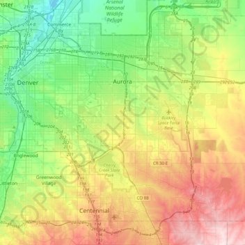
Naam: Topografische kaart Aurora, hoogte, reliëf.
Locatie: Aurora, Adams County, Colorado, United States (39.55106 -104.88654 39.82697 -104.48891)
Gemiddelde hoogte: 1.691 m
Minimale hoogte: 1.548 m
Maximale hoogte: 1.930 m