
Topografische kaart Eyjafjallajökull
Interactieve kaart
Klik op de kaart om de hoogte weer te geven.
Over deze kaart
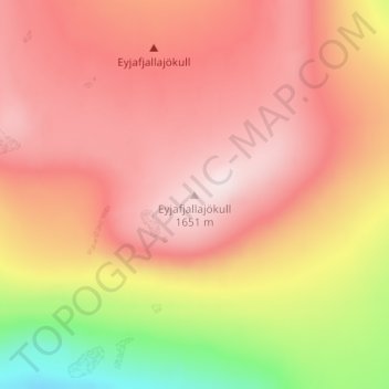
Naam: Topografische kaart Eyjafjallajökull, hoogte, reliëf.
Gemiddelde hoogte: 1.459 m
Minimale hoogte: 1.162 m
Maximale hoogte: 1.628 m
Eyjafjallajökull (Icelandic: [ˈeiːjaˌfjat͡ɬaˌjœːkʏt͡ɬ] ; lit. 'glacier of the mountains of the islands'), sometimes referred to by the numeronym E15, is one of the smaller ice caps of Iceland, north of Skógar and west of Mýrdalsjökull. The ice cap covers the caldera of a volcano with a summit elevation of 1,651 metres (5,417 ft). The volcano has erupted relatively frequently since the Last Glacial Period, most recently in 2010, when, although relatively small for a volcanic eruption, it caused enormous disruption to air travel across northern and western Europe for a week.
Andere topografische kaarten
Klik op een kaart om zijn topografie, zijn hoogte en zijn reliëf te bekijken.
Skogafoss
Skogafoss, Rangárþing eystra, Southern Region, Iceland
Gemiddelde hoogte: 145 m
Eyjafjallajökull
Eyjafjallajökull, Rangárþing eystra, Southern Region, Iceland
Gemiddelde hoogte: 821 m