
Topografische kaart Churchville
Interactieve kaart
Klik op de kaart om de hoogte weer te geven.
Over deze kaart
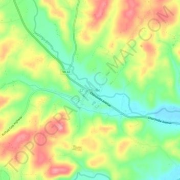
Naam: Topografische kaart Churchville, hoogte, reliëf.
Locatie: Churchville, Augusta County, Virginia, 24421, United States (38.20624 -79.18226 38.24624 -79.14226)
Gemiddelde hoogte: 467 m
Minimale hoogte: 420 m
Maximale hoogte: 518 m
Andere topografische kaarten
Klik op een kaart om zijn topografie, zijn hoogte en zijn reliëf te bekijken.
Annex
United States > Virginia > Augusta County
Annex, Augusta County, Virginia, 24482, United States
Gemiddelde hoogte: 393 m
Copelands Tetons
United States > Virginia > Augusta County
Copelands Tetons, Augusta County, Virginia, 22980-4738, United States
Gemiddelde hoogte: 573 m
Reddish Knob
United States > Virginia > Augusta County
Reddish Knob, Augusta County, Virginia, United States
Gemiddelde hoogte: 1.120 m